.jpg)
Lighthouses on the Isle of Wight
Lighthouses on the Isle of Wight are major landmarks here on the Island. It is an ideal location for lighthouse enthusiasts to visit. Below you will see information regarding the lighthouses on the Isle of Wight.
NEEDLES LIGHTHOUSE
Set in the western approaches to the Isle of Wight, the Needles form a narrow chalky peninsula which rises from jagged rocks to 120m cliffs. These rocks have always been a hazard to ships making their way up the Solent to Portsmouth and Southampton Water.
In 1781 merchants and shipowners petitioned Trinity House for a lighthouse. They obtained a patent in January 1782 which directed that lights should be kept burning in the nightseason whereby seafaring men and mariners might take notice and avoid danger..... and ships and other vessels of war might safely cruise during the night season in the British Channel.
Negotiations must have failed because it was not until 1785 that Trinity House erected to the designs of R. Jupp, for 30 years surveyor to the East India Company, three lighthouses at the Needles, St. Catherine´s Point and Hurst Point. The Needles tower was lighted on the 29th September 1786. As the tower was situated on top of a cliff overhanging Scratchell´s Bay, the light which was 144m above sea level was often obscured by sea mists and fog and was therefore of limited use to mariners.
In 1859 Trinity House planned a new lighthouse to be built on the outermost of the chalk rocks near sea level. It was designed by James Walker and cost £20,000. The circular granite tower has perpendicular sides and is 33.25m high, of uniform diameter with an unevenly stepped base to break the waves and discourage sea sweeping up the tower. The wall varies from 1.07m in thickness at the entrance, to 0.61m at the top. Much of the base rock was cut away to form the foundation and cellars and storehouses were excavated in the chalk.
The light at the Needles has two white, two red and one green sector, with one of the red sectors intensified, these are set out as follows:
- Red intensified sector shore to 300 marks the St Anthony Rocks
- White sector 300 to 083 marks the approach to the Needles Channel from the west
- Red sector 083 to 212 marks the Shingles Bank
- White sector 212 to 217 marks the course through the Needles Channel
- Green sector 217 to 224 marks a safe channel past the Hatherwood Rocks and the Warden Ledge
A helipad was built on top of the Needles Lighthouse in 1987.
The Needles Lighthouse was automated in 1994, the keepers left the lighthouse for the last time on 8th December. Needles was the last Trinity House lighthouse powered by 100V DC electricity from it´s own generators; to enable the automation to be carried out mains power has been supplied via a subsea cable from the Needles Battery, which provides 240V AC power for the new equipment.
The original optic with it´s arrangements of green and red glass giving the different coloured sectors of light remained after automation but a new three position lampchanger was installed with two 1500W 240V main lamps and a 24V battery powered emergency lamp.
The supertyphon air driven fog signal was replaced by two Honeywell ELG 500 Hz directional fog signals controlled by means of a fog detector. The emitter stacks were mounted at gallery level outside the helideck structure.
The Needles is monitored and controlled via a cellphone telemetry link from the Trinity House Operations Control Centre at Harwich, Essex.
Specifications:
Established : 1786
Height Of Tower: 31 Metres
Height Of Light Above Mean High Water: 24 Metres
Automated: 1994
Lamp: 1500W 240V
Optic: 2nd Order 700Mm Fixed Lens
Character: White, Red And Green Group Occurring Twice Every 20 Seconds (Light 14 Seconds, Eclipse 2 Seconds, Light 2 Seconds, Eclipse 2 Seconds)
Intensity: Red (Intensified) 3,950 Candela, White 12,300 Candela, Red 1,800 Candela, Green 2,680 Candela
Range Of Light: Red (Intensified) 17 Sea Miles, White 17 Sea Miles, Red 14 Sea Miles, Green 14 Sea Miles
Fog Signal Character: Sounding Twice Every 30 Seconds
ST CATHERINE´S LIGHTHOUSE
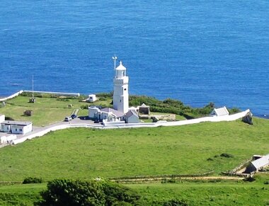
St Catherine´s Lighthouse is situated at Niton Undercliffe, 5 miles from Ventnor on the Isle of Wight and comprises a white octagonal tower with 94 steps up to the lantern. The main light, visible for up to 30 nautical miles in clear weather is the third most powerful light in the Trinity House Service giving a guide to shipping in the Channel as well as vessels approaching the Solent.
There is a fixed red subsidiary light displayed from a window 7 metres below the main light and shown westward over the Atherfield Ledge. It is visible for 17 miles in clear weather, and was first exhibited in 1904. Both lights are electric, and standby battery lights are provided in case of a power failure.
A small light was first set up at St. Catherine´s in about 1323 by Walter de Godyton. He erected a chapel and added an endowment for a priest to say Masses for his family and to exhibit lights at night to warn ships from approaching too near this dangerous coast, both purposes being fulfilled until about 1530 when the Reformation swept away the endowment. Neither the present lighthouse tower lighted in March 1840, nor the chapel of which the ruins remain, held these ancient lights. The present tower was constructed in 1838 following the loss of the sailing ship CLARENDON on rocks near the site of the present lighthouse. The lighthouse was built of ashlar stone with dressed quoins and was carried up from a base plinth as a 3 tier octagon, diminishing by stages. The elevation of the light proved to be too high, as the lantern frequently became mist capped and in 1875 it was decided to lower the light 13 metres by taking about 6 metres out of the uppermost section of the tower and about 7 metres out of the middle tier, which destroyed its beauty and made it appear dwarfed.
At that time the fog signal house was situated near the edge of the cliff but owing to erosion and cliff settlements the building developed such serious cracks that in 1932 it became necessary to find a new place for the fog signal, which was eventually mounted on a lower tower annexed to the front of the lighthouse tower, and built as a small replica. The resultant effect has been to give a well proportioned step down between the two towers which are now expressively referred to by the local inhabitants as "The Cow and the Calf". The fog signal was discontinued in 1987.
A tragic incident took place at the station during the Second World War. On the 1st June 1943 a bombing raid destroyed the engine house killing the three keepers on duty who had taken shelter in the building. R.T. Grenfell, C. Tomkins and W.E. Jones were buried in the local cemetery at Niton village and a plaque in remembrance of them is displayed on the ground floor of the main tower.
St Catherine’s Lighthouse was automated in 1997 with the keepers leaving the lighthouse on 30 July.
The lighthouse had been a weather reporting station for the Meteorological Office for some years;the keepers made hourly reports which included the temperature, humidity, cloud height and formation and wind direction and force. Following demanning of the lighthouse an automatic weather reporting station was installed which sends details of the weather conditions to the Met. Office.
The lighthouse itself is now monitored and controlled from the Trinity House Operations Control Centre at Harwich in Essex.
Specifications:
Established: 1323
Height Of Tower: 27 Metres
Height Of Light Above Mean High Water: 41 Metres
Automated: 30 July 1997
Lamp: 2 X 400 W Mbi Lamp
Optic: 2nd Order 4 Panel Catadioptric
Character: One White Flash Every 5 Seconds
Intensity: 927,000 Candela
Range Of Light: 26 Sea Miles
EGYPT POINT (This lighthouse is not operational)
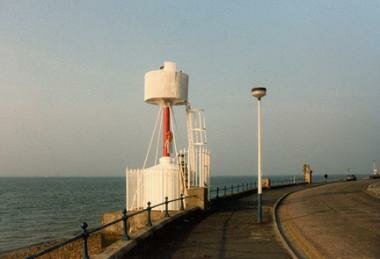
Location: Cowes
Tower Height: 25 ft.
Description of Tower: Red post with white lantern, on round white base.
Date Established: 1897
Date Present Tower Built: 1897
Date Deactivated: 1989
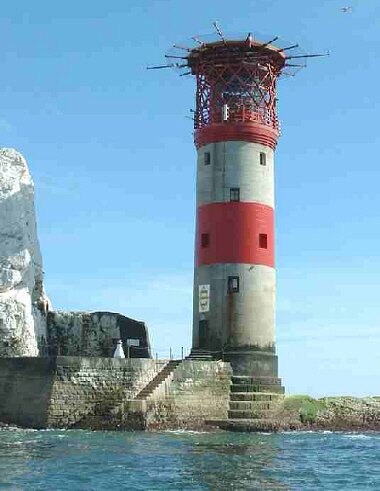
THE NAB TOWER
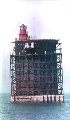
This curious looking object a few miles to the South East of Bembridge started life during the First World War as part of an anti-submarine defence system. During 1916 the British Admiralty, alarmed by the losses of allied merchant shipping to German U-boats designed four or six towers that were to be built and positioned in the Straits of Dover. They would be linked together with steel nets and armed with two 4" guns. However when the Armistice was signed in 1918 only one of the planned towers was anywhere near completion. The others were dismantled, but what was to be done with this 92 foot tall metal cylinder (costing one million pounds sterling, in those days), sitting on its raft of concrete?
Until the end of the first World War the dangerous Nab Rock had been marked by a lightship, and it was decided to replace this with a fixed lighthouse. The new lighthouse was floated into position and the concrete raft (189ft long, by 150ft wide, by 80ft deep) flooded so the tower could sit on a shingle bank near the Nab Rock.
As can be seen from the photograph the tower took up a distinct angle (3 degrees from the vertical towards the northeast) when it settled. The lighthouse used to be manned by a crew of four, but in common with all Britain´s lighthouses it is now unmanned and is fully automated.
During WWII the Nab was armed with two 40mm Bofors Guns and was credited with shooting down 3½ enemy aircraft (the half was shared with a passing ship).
The tower still provides a welcoming sight to seafarers returning to the Solent at the end of their voyage. In November 1999 the Nab was hit by a freighter, the Dole-America, carrying a cargo of bananas and pineapples. The ship was badly damaged and only avoided sinking by being run-aground. The base of the tower suffered only superficial damage.
English & Welsh lighthouses, including lighthouses on the Isle of Wight, are run and maintained by Trinity House.


Articles
Isle of Wight Bat Hospital
The Isle Of Wight Bat Hospital was formed in 1997 ...
Isle of Wight Events 2012
Isle of Wight events for 2012. Whatever your inter...